Ditapis dengan

Pemetaan Situasi Puncak G. Rokatenda Pulau Palue Kab. Sikka Flores Tengah, Nu…
Gunung Rokatenda terletak di pulau Palue termasuk wilayah kecamatan Maumere kabupaten Sikka (Flores Tengah) provinsi Nusa Tenggara Timur. Terletak pada posisi geografi 8°19' LS dan 121°42,5 BT (Atlas Top. Nederl 1938. Lembar 27). Puncak G. Rokatenda pernah dipetakan pada 1964 oleh Sdr. Samud W. di sekitar puncak kubah Lava 1961 menuju ke pantai. Pada 1981 Sdr. Soedarso dan Sdr. Iriyanto dari …
- Edisi
- -
- ISBN/ISSN
- -
- Deskripsi Fisik
- 6 hlm.; gbr.; peta
- Judul Seri
- -
- No. Panggil
- PVG G.85-5

Laporan Pengamatan Visual Kegiatan Gunungapi G. Sangeangapi Tgl. 29 mei 1985
G. Sangeangapi adalah salah satu Gunungapi aktip berbentuk strato yang mempunyai kawah, dengan tinggi + 1949 meter di atas permukaan laut. Sesuai dengan SPPD dari Bandung atas nama : sdr.M.Endang Ilyas, sdr.H.Abdul Wahab dan sdr. Wayan Nongos Tapayasa, maka pada tanggal 29 Mei 1985 dilakukan pemeriksaan kawah/pengamatan visual langsung ke puncak/ke kawah Gunung Sangeangapi. Adapun maksud dan tu…
- Edisi
- -
- ISBN/ISSN
- -
- Deskripsi Fisik
- 4 hlm.
- Judul Seri
- -
- No. Panggil
- PVG G.85-08
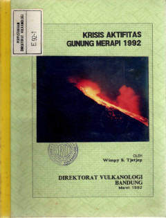
Krisis Aktifitas Gunung Merapi 1992
Aktifitas Merapi 1992, mulai teramati secara visual dari pos Pengamatan Gunung Merapi sejak 20 Januari dengan hadirnya guguran - guguran lava pijar disisi barat daya puncak Merapi.
- Edisi
- -
- ISBN/ISSN
- -
- Deskripsi Fisik
- 13 hlm
- Judul Seri
- -
- No. Panggil
- PVG E.92-1

Pemetaan Situasi Topografi Puncak G. Sundoro Kab. Temanggung dan Wonosobo Pro…
Dokumentasi peta situasi puncak G.Sundoro yang dimiliki oleh Direktorat Vulkanologi saat ini berupa peta situasi puncak skala 1 : 5000 hasil pengukuran Petugas Dinas Pertambangan Negara, Desember 1921, Oleh karena itu Pemimpin Proyek Pengamatan/Pengawasan dan Pemetaan Gunungapi melalui Kepala Seksi Pemetaan Topografi dan Pengukuran Deformasi Gunungapi menugaskan Sdr. A.R. Sumailani dan penulis …
- Edisi
- -
- ISBN/ISSN
- -
- Deskripsi Fisik
- 10 hlm
- Judul Seri
- -
- No. Panggil
- PVG E.92-2
Laporan Pengamatan Visual Kegiatan Letusan G. Sangeangapi
G. Sangeangapi berada pada posisi 8°11' lin-tang selatan dan 119°03,5' bujur timur. Tepatnya terletak di Pulau Sangeang, Kecamatan Wera, Kabupaten Bima, Propinsi Nusa Tenggara Barat. G. Sangeangapi telah lama dikenal sebagai gunungapi aktif dan berdasarkan sejarah erupsi termasuk Tipe A. G. Sangeangapi telah mengalami beberapa kali peletusan, yang tercatat antara lain: pada tahun 1512, 1715, …
- Edisi
- -
- ISBN/ISSN
- -
- Deskripsi Fisik
- 6 hlm.
- Judul Seri
- -
- No. Panggil
- PVG G.85-9
Laporan Pengumpulan Data Kependudukan Di Dataran Tinggi Dieng
Pendataan pengamatan dan kependudukan di dalam daerah bahaya dan waspada di komplek G.Dieng dan sekitarnya dilakukan dengan cara meneliti dan menginventarisasi dilapangan secara langsung. Pelaksanaan pekerjaan lapangan ini dilakukan oleh tujuh orang petugas Seksi Penyuluhan Gunungapi Direktorat Vulkanologi dengan biaya dibebankan kepada Proyek Pengamatan/Pengawasan dan Pemetaan Gunungapi tahun …
- Edisi
- -
- ISBN/ISSN
- -
- Deskripsi Fisik
- 17 hlm
- Judul Seri
- -
- No. Panggil
- PVG E.92-3
Perubahan Deformasi G. Lamongan Dengan Metoda Dry Tilt
Gunungapi Lamongan dipantau secara terus menerus, baik secara visual dan seismik oleh Seksi Pengamatan Gunungapi Jawa Timur dan Bali dari Pos Pengamatan Gunungapi di G.Meja. Pemantauan dengan metoda "dry tilt" telah dilakukan sejak tahun 1988 oleh Seksi Pemetaan Topografi dan Pengkuran Deformasi, dan pengamatan tersebut dilakukan paling sedikitnya sekali dalam setahun.
- Edisi
- -
- ISBN/ISSN
- -
- Deskripsi Fisik
- 17 hlm
- Judul Seri
- -
- No. Panggil
- PVG E.92-4
Laporan Pengamatan Visual Kegiatan G. Sangeangapi
G. Sangeangapi merupakan gunungapi giat tipe A yang letaknya di P. Sangeang sebelah timur laut P. Sumbawa, masuk wilayah Kabupaten Bima . Sejak 30 Juli 1985 gunungapi ini menunjukkan kegiatannya. Beberapa penyelidikan telah dan sedang dilakukan, sehubungan dengan kegiatan tersebut, yang diantaranya pengamatan visual dan penyelidikan seismik. Secara geografis G. Sangeangapi terletak pada posisi …
- Edisi
- -
- ISBN/ISSN
- -
- Deskripsi Fisik
- 8 hlm.; gbr.; peta
- Judul Seri
- -
- No. Panggil
- PVG G.85-14

Laporan Pemeriksaan Kawah dan Pengukuran Suhu Solfatara G. Rinjani
Berdasarkan Surat Perintah Perjalanan Dinas dari Bandung Nomor. 141/P/84 dan 142/P/84 masing-masing atas nama Ida Made Jelantik dan K Jani Suwartiyasa ditugaskan untuk melakukan pemeriksaan kawah dan pengukuran suhu solfatara Gunung Rinjani. Sebagaimana diketahui bahwa gunung Rinjani adalah gunungapi bentuk strato yang terletak di Pulau Lombok bagian Utara, Nusa Tenggara Barat. Gunungapi ini da…
- Edisi
- -
- ISBN/ISSN
- -
- Deskripsi Fisik
- 3 hlm.
- Judul Seri
- -
- No. Panggil
- PVG G.84-3

Penyelidikan Metoda Terpadu Di Wilayah Merapi Jawa Tengah 1991/1992
Kegiatan Penyelidikan Metoda Terpadu di G.Merapi Jawa - Tengah anggaran tahun 1991/1992 dimulai sejak bulan Juni, September 1991 dan bulan Januari - Februari 1992 dimana bulan - bulan terakhir terjadi peningkatan kegiatan.
- Edisi
- -
- ISBN/ISSN
- -
- Deskripsi Fisik
- 38 hlm
- Judul Seri
- -
- No. Panggil
- PVG E.92-6
 Karya Umum
  Filsafat
  Agama
Agama  Ilmu-ilmu Sosial
  Bahasa
  Ilmu-ilmu Murni
  Ilmu-ilmu Terapan
  Kesenian, Hiburan, dan Olahraga
  Kesusastraan
  Geografi dan Sejarah